Monday, June 29, 2020

Granite – Bedrock of the Earth


Credit:  Linda & Dr. Dick Buscher

1.  John Muir once described the Sierra Nevada Mountain Range of Central California as the “Range of Light” because of the reflected sunlight that always seems to glisten from the many majestic peaks.  He said that these majestic granite peaks were “so luminous, that it seems to be not clothed with light, but wholly composed of it, like the wall of some celestial city.”  


Credit:  Linda & Dr. Dick Buscher

2.  Granite is so common here that it is called the “stone heart of the Sierra.”  Geologists believe that these exposed mountain top granite peaks extend downward into the earths crust for over 20 miles.  In fact, granite is a prime product of tectonic plate collisions, forming the major part of the North American Continent’s foundation - the bedrock.  Massive outcroppings of granite can be found in over thirty states of the United States.  


 Credit:  Linda & Dr. Dick Buscher

3.  Granite is an igneous rock, formed by the solidification and cooling of magma some 20 – 140 miles below the earth’s crust.  In this underground region temperatures reach 1,500∞ C. forming pockets of liquid magma. Three factors come into play, allowing the magma to begin its journey toward the surface; the underground lithostatic pressure, some 35,000 times greater than atmospheric pressure, the magma being less dense than the surrounding solid rock, resulting in the magma “floating” upward and the melting of adjacent rock during its upward journey creating spaces into which the magma flows.


Credit:  Linda & Dr. Dick Buscher

4.  As the magma cools to about 1000∞ C, small crystals of minerals such as feldspar, quartz, mica and more begin to form.  The process is very slow and as the different mineral crystals begin to grow together, they begin to create an interlocking atomic framework.  After a long cooling period, the molten magma solidifies, creating a hard stone made totally of inter-grown crystals.  It is these interlocking crystals that give granite its unique glitter and sparkle.


Credit:  Linda & Dr. Dick Buscher

5.  Some of the highest mountain ranges in the world (the Andes, the Himalayas as well as the Rockies) are composed of massive granite mountains.  In the United States, both Mt. Whitney (14,505ft/4,421m) and Mt. McKinley (20,320 ft/ 6,194m) are both granite plutons, part of an even more massive granite blatholith.  And when the forces of erosion begin to remove softer rock layers interspersed with the hard granite, magnificent valleys are formed like the Yosemite Valley shown here.  


Credit:  Linda & Dr. Dick Buscher

6.  In the Yosemite Valley the force of erosion responsible for carving such a natural paradise were massive glaciers.  For the last 30 million years glaciers have moved into and then retreated from the valley.  The last period of glaciation occurred during the Pleistocene Epoch ending only 11,700 years ago.  Ahead of the advancing ice is pushed tons of gravel, sand and granite boulders known as till which marks the end of the glacial advance.  


Credit:  Linda & Dr. Dick Buscher

7.  Other forces of erosion and weathering are always working to tear down the massive granite mountains and outcroppings.  Exfoliation joints of sheet joints are parallel surface fractures in granite rock that lead to the “peeling off” of the rock surface similar to that of peeling off the layers of an onion.  Exfoliation joints are common in many different geological areas and geologists continue to work on an agreeable theory of exfoliation joint formation. 


Credit:  Linda & Dr. Dick Buscher

8.   Exfoliation has causes the formation of some of the most spectacular of granite mountain features known as granite exfoliation domes.  These unique natural structures are found in granite mountain ranges worldwide.  From Corcovado Mountain in Rio de Janeiro, Brazil, to Stone Mountain in American state of Georgia, to Half Dome (shown here) of the Sierra Nevada Mountains, granite domes create awe-inspiriting natural features unique to granite.  


Credit:  Linda & Dr. Dick Buscher

9.  In many areas where granite bedrock is close to the surface, topsoil is very shallow.  Plant roots, like those of this ponderosa pine tree (Pinus ponderosa), seek any small crack in the hard granite rock to anchor the majestic tree to the hillside.   The intrusion of plant roots continues the weathering process of these great, granite mountains.  


Credit:  Linda & Dr. Dick Buscher

10.  Tree roots and lichen work on this group of granite boulders in the mountainous areas near Keystone, South Dakota.  These forms of biological weathering work with the forces of erosion to constantly break down the massive mountains of granite   


Credit:  Linda & Dr. Dick Buscher

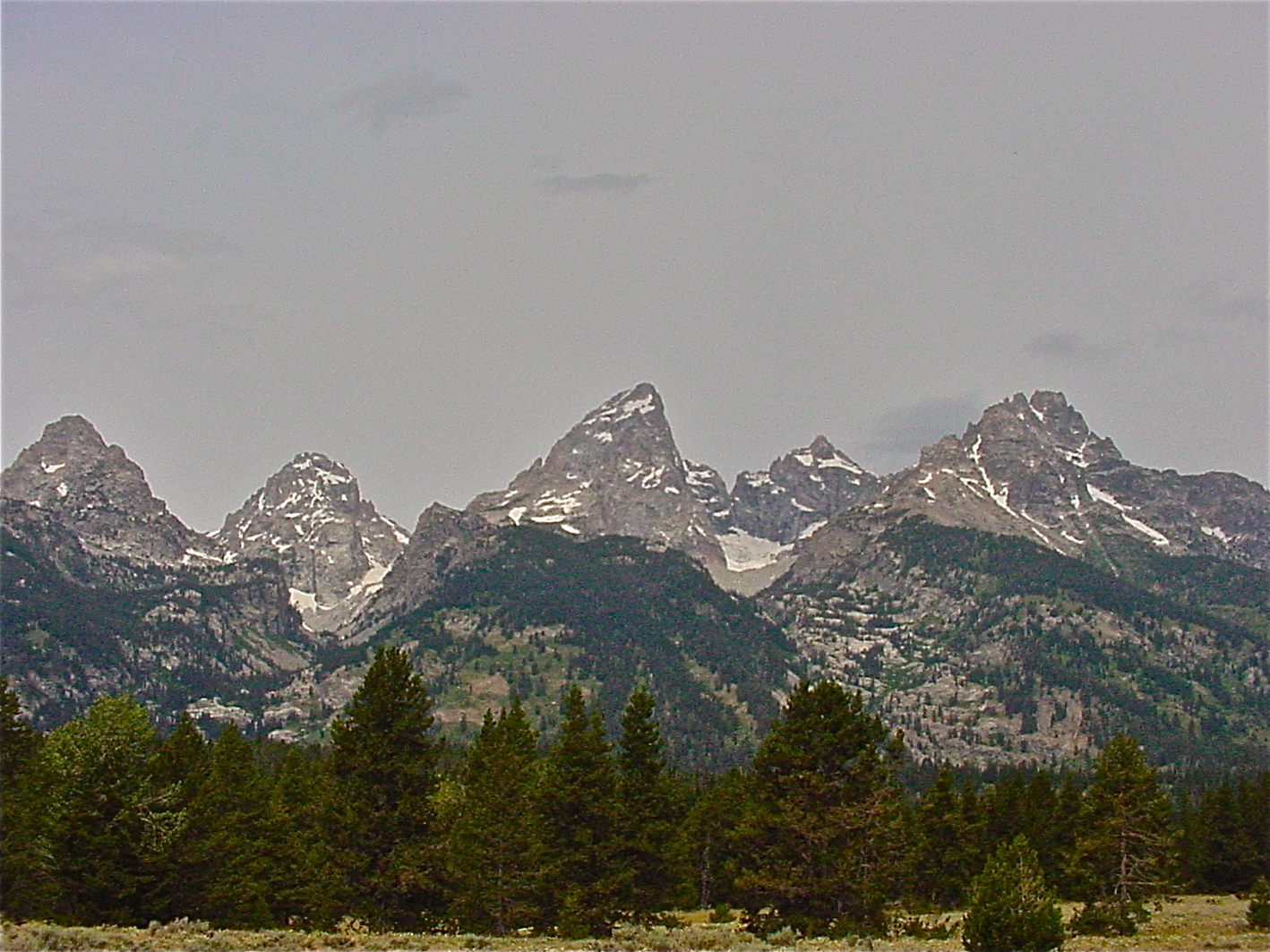
11.  The Grand Teton is the highest mountain in the Grant Teton National Park of Wyoming.  Here silica-rich magma crystallized deep underground and the moved upward to form the park’s highest granite peaks. 


Credit:  Linda & Dr. Dick Buscher

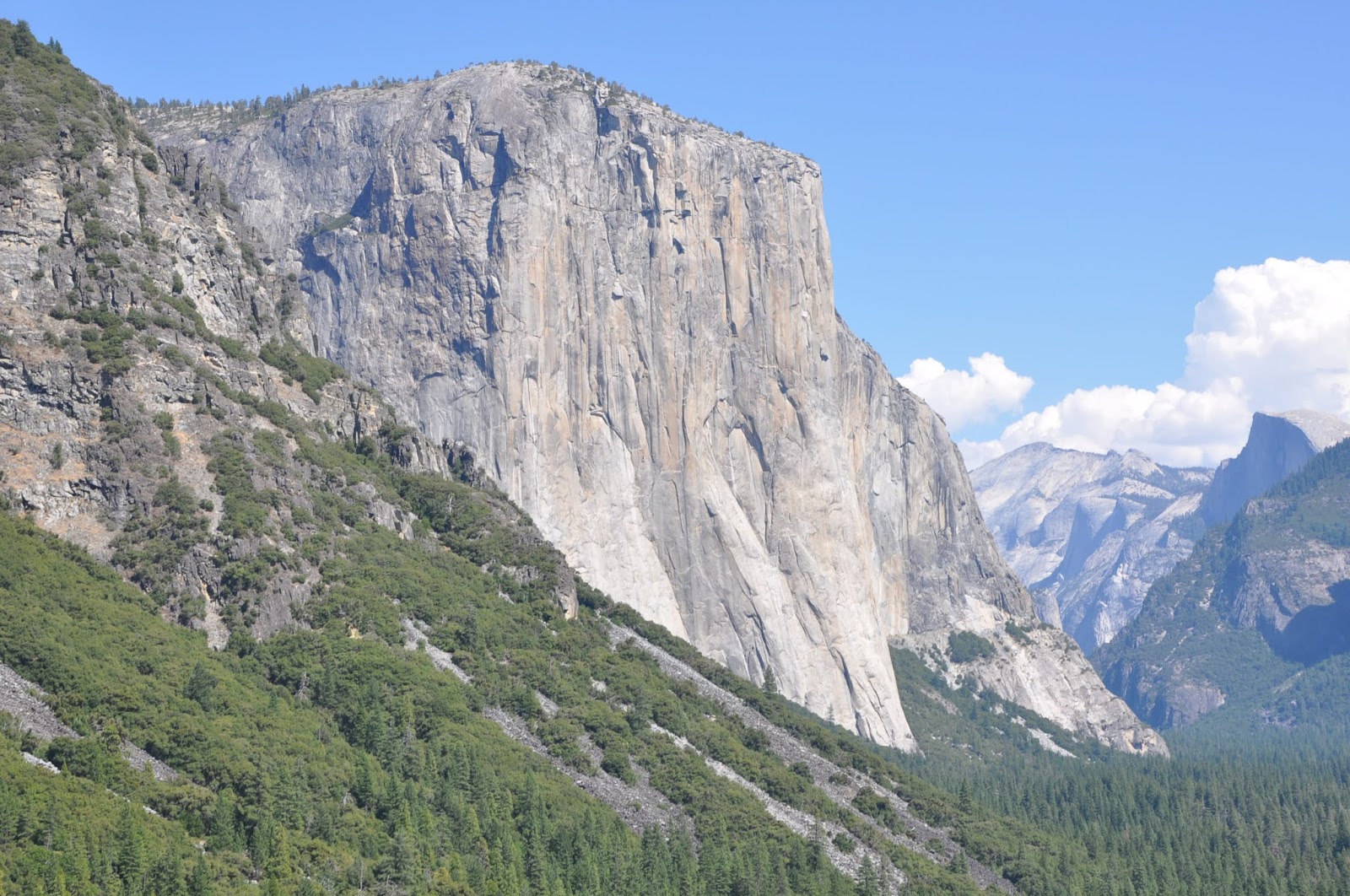
12.  El Capitan is a granite monolith found in Yosemite National Park.  It rises some 3,000 feet (900 m) from the floor of the Yosemite Valley.  The coarse grain granite that makes up the marvelous wall is approximately 100 million years old.  It is the largest monolith of granite in the world.


Credit:  Linda & Dr. Dick Buscher

13.  El Capitan is also one of the favorite rock climbing venues in the world.  It was first climbed in 1958 and today over 70 big wall routes allow climbers from all over the world to make the ascent.  The 3,000-foot climb has been made in less than 2 hours but the average climbing party takes between 4 – 6 days.  During the climbing season, from spring to fall, dozens of climbers can be seen on the face of this granite giant, moving slowly toward the towering summit.


Credit:  Linda & Dr. Dick Buscher

14.  The granite mountains of the world are not only used by outdoor enthusiasts but also by the world’s great rock sculptors.  The giant heads of the four American Presidents were carved by Gutzon and Lincoln Borglum into the granite face of Mt Rushmore in South Dakota.  The Precambrian period batholith magma rose into pre-existing mica schist some 1.6 billion years ago resulting in this granite outcropping.  Carving of the monument began in 1927 and was stopped in 1941.


Credit:  Linda & Dr. Dick Buscher

15.  Thus is the story of the granite, a major product of tectonic plate collision.  Mankind has used it for centuries to build his homes as well as his most spectacular buildings.  And, because it is so naturally hard, it has resisted the forces of erosion and weathering for eons resulting in the formation of some of the most spectacular places on earth.

Thursday, June 11, 2020

Coronado National Memorial Park


Credit: NPS
    1.        Along the international border between the United States and Mexico, on the southeastern slope of a sky island known as the Huachuca (Wah-choo-ka) Mountains and south of the small desert town of Sierra Vista, Arizona, the National Park System operates and oversees a unique and remote national memorial park.   There are thirty national memorials across the United States and some are quite famous, like the Lincoln Memorial, Pearl Harbor Memorial and the Martin Luther King Memorial.   But this Arizona high desert national memorial is dedicated to people and events that occurred some 236 years before the United States was even a country.  It commemorates one of the greatest European expeditions ever to take place in the Americas - the 1540 - 1542 expedition in search of the Cibola - the fabled Seven Cities of Gold by a Spanish army led by Francisco Vásquez de Coronado.   


Credit: NPS
2.   The Coronado National Memorial is a  4,830.22 acres (19.5472 km2) park and preserve originally established as an international park in 1939 in a hope to “advance the relationship of the United States and Mexico upon a friendly basis of cultural understanding…” to encourage the advancement of both counties common interests.  The park was located here because the mountains that encompass Coronado National Memorial overlook the vast San Pedro River Valley, shown above - the valley Coronado and his men traveled when they first entered today’s United States from Mexico some 67 years before the founding of the English colony of Jamestown, VA.


Credit: University of Southern Florida
3.   The story of the 1540 - 1542 Coronado’s Expedition has its genesis in the conquest of the Mexica (Aztec) people during the siege of 1519 - 1521 and led by Hernán Cortés, shown above.  After the conquest, Cortés had to return to Spain to face charges of improper treatment of the Mexica people.  In his absence, a new group of Spanish conquistadors, priests, soldiers and merchants arrived in the Valley of Mexico to govern and build a permanent Spanish colony in the New World.  

 
Credit: NPS & artist José Cisneros
4.  Now new men of Spain or under the ownership of Spain began to flow into what would become the modern countries of Mexico and the United States.  A group of four Spanish conquistadors along with a Black, Moorish slave known in history as Esteban or Estevanico, survived a shipwreck in the Gulf of Mexico and wandered across modern Texas and the deserts of the American Southwest and Mexico between 1528 - 1536 before coming upon a group of Spanish soldiers who rescued them in northern Mexico.  During their odyssey they were told of fabled Seven Cities of Gold, called Cibola, that according to the native people with whom they spoke, lay further to the north.  An artist rendition of Esteban is shown above. 


Credit: Linda & Dr. Dick Buscher
5.  A Spanish Franciscan friar named Fray Marcos de Niza had arrived in the City of Mexico in 1531 and in 1538 agreed to accompany the Moorish slave Esteban to the unknown regions to the north in search of the Seven Cities of Gold.  Historians believe that in May 1539 Esteban and Fray Marcos de Niza became the first African and first European to enter the southwest region of what would become the United States along the southern boundary of today’s Arizona.  A monument to their entry is located near the small ghost mining town of Lochiel, Arizona and is shown above.  The result of their journey was that Esteban was killed by the Zuni Indians in what is today’s northern New Mexico and Fray de Niza rushed back to City of Mexico and reported that he did actually did see Cibola - the Seven Cities of Gold! 


Credit: NPS
6.  Hernán Cortés once wrote, “We Spaniards know a sickness of the heart that only gold can cure” and Fray de Niza’s arrival back into the capital city set the hearts of this new generation of young conquistadors a blaze.  A thirty year old noble, Francisco Vázquez de Coronado was selected by then Governor Antonio de Mendoza to lead a large Spanish army of soldiers and native porters to the north to claim these golden cities for the King of Spain.  On February 22, 1540 Francisco Vázquez de Coronado left Compostela with a army of 336 Spanish conquistadors, 3 women and 761 Indian porters north to conquer Cibola under the banner of the Castilian flag.  Coronado. Fray de Niza and a small advanced portion of his army moved north ahead of the main part of his army.  This advanced group entered what is now the State of Arizona near today’s Coronado National Memorial Park along the San Pedro River Valley May 1540.


Credit: Linda & Dr. Dick Buscher
7.  The two year journey of Coronado and a small part of this army into the American southwest and plains provide many “first” in the annals of American history.   In the small pueblo known as Hawikuh in today’s northeastern New Mexico, the first battle between Europeans and Native Americans occurred on July 7, 1540.  Since Hawikuh, shown in ruins in the above 2006 photo,  was simply a small pueblo made of mud and stone and not of gold, distrust in Fray de Niza’s story of Cibola began to grow.  But Coronado was now injured having received a hail of stones thrown at his head and an arrow to his leg.  While recovering from his battle injuries, he ordered his officers to explore.  Twenty-two year old Hernando de Alvarado the designated “Captain of the Artillery”, traveled to the northeast and while entering today’s states of Texas and Oklahoma became the first European to see and dine on the American buffalo.  Captain Don García López de Cárdenas, led by a group of Hopi Indians, became the first European to gaze into the depths of the Grand Canyon. 


Credit: NPS
8. Coronado would recover from his wounds.  His first order of business was to send Fray Marcos de Niza back to the City of Mexico for his own safety as his men had become convinced the good Fray had lied about Cibola.   But Coronado and his army of conquistodors were soon back on the trail in search of Cibola.  This time they were told of a “Golden City” to the northeast known as Quivira.  They began their march to Quivira on April 23, 1541.  When they arrived at this pueblo, somewhere on the plains of central Kansas, they once again found only a poor village made of mud and stone.   Disheartened, Coronado and his men  turned their horses south and began their journey back to the City of Mexico arriving in April 1542. He was labeled a failure for not finding gold and died on September 22, 1554 never receiving the accolades for his accomplishments during his journey of exploration.   And even though Coronado did not find the Seven Cities of Gold, he and his men did open the northern lands for a future generation of Spanish soldiers, priests and settlers to travel there and begin to establish permanent Spanish settlements at the beginning of the 17th Century.  Some historians have argued that United States history actually began with the Coronado Expedition as he and/or his men were the first Europeans to travel through the future states of California, Arizona, New Mexico, Texas, Oklahoma and Kansas.


Credit: NPS
9.  The Huachuca Mountains, home to the Coronado National Memorial Park, is one of 27 Sky Islands found in the Madera Sky Island Archipelago.  It is a region of over 70,000 square miles (181,299 km²) that is the biological meeting point of two great mountain ranges - the Rocky Mountains of the north and the Sierra Madre Mountains of the south.  Here over the eons of geological time the valley floors have sunk resulting in sky island mountain peaks rising to over 9,000 feet in elevation above the Sonoran Desert floor.  The Huachuca Mountains, and Indian name that translates to mean “mountain of water” are within the boundary of the Coronado National Forest and the highest peak of the Huachuca Mountains rises to an elevation of 9,466 ft (2,885 m).  Coronado National Memorial Park sits at the eastern end of the Huachuca Mountains and the highest  peak within the park, known as Coronado Peak, rises to an elevation of 6,864 feet (2092 m).


Credit: NPS
10.  Mexico was unable to ever develop their side of the intended international park.  So, in July 1952 the United Staes Congress removed “international” from the park’s name and authorized designation of the park as a national Memorial.  President Harry S. Truman officially designed the Coronado National Memorial Park on November 5, 1952.  Finally, Coronado National Memorial Park was placed on the National Register of Historic Places on October 15, 1966.  At an average elevation within the park of 4,000 feet (1,219 m), the park preserves a unique and desolate desert landscape.


Credit: NPS
11.  One of the more adventurous experiences while visiting the national memorial park is a visit to Coronado Cave.  A short hike brings the explorer to a 600 foot (183 m) long, 20 foot (6 m) high limestone cave.  This spectacular cave, as shown above, requires no rappelling or squeezing through tight passageways but just a casual walk through rooms and areas 6 to 70 feet (2 - 21 m) wide.  Old West legends suggest that native Apache Indians, including the great Chiricahua Apache shaman, Geronimo, often camped and hid out in Coronado Cave during the Apache Wars of 1849 - 1886.


Credit: NPS
12. Within the boundary of the Coronado National Memorial a vast and diverse community of desert plants thrive.  Emory oaks and Gambel oak trees dominate a large part of the park.  Scrubland vegetation as well as non-native grasslands dominate parts of the lower elevations of the land.  Various yucca plants, like those shown above, and other high Sonoran Desert vegetation species are also common within the park.  In such a rugged and isolated region, 36 species of reptiles, 7 species of amphibians, 170 species of birds and 44 species of mammals are all found at Coronado National Memorial Park.


Credit: NPS
13.  Coronado National Memorial Park commemorates one of the greatest explorations ever to occur on the North American continent.  The San Pedro River Valley was one of the super highways of the 1540s and Francisco Vázquez de Coronado and his men used in in search of gold.   The memorial park is not highly visited, receiving some 5.5 million fewer visitors than the Grand Canyon.  But for those who choose to come, they will be rewarded with a peaceful adventure in one of the most desolate yet beautiful desert parks in America. 


More information - https://www.americansouthwest.net/arizona/coronado/national_memorial.html