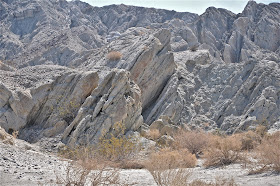
The trip from Phoenix to Los Angles by way of Interstate 10 is not known for its awe-inspiring scenery nor great, recreational “pit-stops”. Yet the truth is that once the LA bound traveler drops into the Coachella Valley near Indio, CA, a fascinating, family friendly geological excursion lies just to the north of the interstate freeway that is always packed with thousands of cars rushing westward toward the ocean.
Here a small range of rugged mountains, known as the Indio Hills, arise from the desert soil and runs parallel along side of the busy freeway for nearly 20-miles. These mountains are the visual “expression” of the world famous San Andreas Fault and mark the line in this valley in which the Pacific and North American Continental Plates come crashing together.
The constant grinding of the two continental plates into each other in this Indio Hills area has resulted in an earthquake fault zone made up of unique geological formations. Massive rocks that lie within 25 yards of each other thrust upward in opposing directions giving evidence to the tremendous geological forces at work when continental plates collide. Rock formations known, as windows, arches and wind caves are common throughout the fault zone. Many slot canyons are found here and create narrow trails that allow hikers in theory to rest one hand on the boulders of the North American Plate while resting their other hand on the Pacific Plate.
In addition a green belt of vegetation thrives along this fault line as underground water seeps toward the surface creating eleven, distinct desert oases. Here in these green havens of the desert are found rare stands of the ancient California Fan Palm, the only palm tree native to western North America.
Visiting this section of the 800-mile long San Andreas Fault is easy to do since the Indio Hills are so close to the freeway. The first option is to stop at the Coachella Valley Preserve located within 3 miles north of the freeway. Information about the San Andreas Fault and short hiking trails that pass over the shallow pools of cool water and beneath the many tall palm trees are in this 20,000-acre palm oases. The visitor center closes during the hot summer but the preserve is open daily for the hiking and the picnicking public.
The best option, we believe, is to purchase a tour of the San Andreas Fault Zone from one of the many tour companies available. Our suggestion is to check out Desert Adventures Eco-Tours because this tour company has exclusive rights to enter an area in the Indio Hills known as the Metate Ranch. This historic, desolate ranch is considered to be the prime area of unique and spectacular geological formations. The afternoon summer heat can be brutal but early morning tours are available and comfortable.
So next time you looking for a way to break up the drive to LA, consider stopping and visiting the famous San Andreas Fault. Get out of your car and explore for yourself this spectacular and unique geological region.
Arizona Earthquake History -
http://earthquake.usgs.gov/earthquakes/states/arizona/history.php
Keep track of earthquakes in or near Arizona -
http://earthquaketrack.com/p/united-states/arizona/recent


No comments:
Post a Comment