Credit: Arizona Game & Fish
I have always felt that I was incredibly fortunate to live my adult life in the Sonoran Desert with its spectacular landscapes, its vast varieties of unique plants and animals and its endless display of soul touching sunsets. And after almost 50 years of calling the magnificent desert home, to see for the first time bald eagles nesting in a saguaro is just the ultimate gift from our desert. The story of their discovery recently showed up in the Arizona Republic. We have copied that their story here... Enjoy this rare and special gift of the Sonoran Desert.
Erin Stone, Arizona Republic Published 4:46 p.m. MT April 16, 2020
A bald eagle nest in a saguaro cactus, the first time such a scene has ever been documented. (Photo: Arizona Game and Fish Department)
When Kenneth “Tuk” Jacobson got a call about a bald eagle nesting in a saguaro cactus, he had his doubts.
For one, as Arizona Game and Fish Department’s raptor management coordinator, he often received calls from the public about strange nesting situations. They were usually inaccurate.
Secondly, though biologists had long suspected bald eagles use saguaro cactuses as nesting sites, researchers had never documented such a sight in more than three decades of concerted research.
When Jacobson followed the tip and got on the ground at the site near a central Arizona reservoir, he saw the unprecedented scene with his own eyes. In the crook of the arms of a huge saguaro cactus, a bald eagle was perched on a sprawling nest made of sticks and other vegetation.
A few days later, he and his team did a helicopter survey to see the nest from above. They were further delighted to find that the pair of bald eagles had several eaglets in the nest — an indication of both the health of the nesting pair and bald eagle population growth as a whole.
“It was super exciting,” Jacobson said. “When people think of saguaro cactuses they think of Arizona. Then you have a bald eagle in the desert in a saguaro. I don’t know how much more Arizona you can get than that.”
Jacobson has watched the iconic birds return from near extinction throughout his nearly 20-year career as a wildlife biologist with Arizona Game and Fish.
“The bald eagle population was very small back in the 1970s — we had only 11 breeding areas, most of those on the lower Salt and Verde rivers," Jacobson said. “We’ve watched that population grow up through the entire river system to central Arizona. As this population continues to grow, we’re starting to see them in more and more areas using more and more unique substrates.”
When he started with the agency in 2002, Jacobson worked with John Koloszar, who ran the bald eagle program before him. Koloszar would often tell him to keep an eye on saguaros for signs of nesting eagles.
The imperiled raptors have made a remarkable comeback in Arizona, from fewer than a half-dozen nests in 1970 to 89 nests in 2019. For 18 years, per Koloszar’s advice, Jacobson has kept an eye out for bald eagles nesting in saguaros.
While there have been confirmed sightings of bald eagles nesting in the similarly columnar Cardon and Hecho cactuses in Mexico, biologists have been searching for a pair of bald eagles nesting in an Arizona saguaro for decades without success.
There had only been one documented case of bald eagles nesting in saguaros back in 1937, Jacobson said—and that historical record only noted empty nests with no eaglets or other indication of activity.
Though the population has rebounded, naturalists continue to protect the birds. That's why Jacobson isn't disclosing the saguaro's exact location, saying, "We want to share the news, but we don't want to attract a bunch of people and cause problems for the birds."
“When we started really looking at bald eagles in Arizona in the 1970s, we had it in the back of our minds as being possible, but as we surveyed the state for the last over 30 years, a saguaro nesting eagle was never documented or seen or identified,” Jacobson said. “I think finally seeing them nesting in a saguaro cactus is part of the story of their growth as a population as a whole. It’s a good sign.”
Credit: National Parks Service
1. The Colorado Plateau is a geological wonderland that encompasses 130,000 square miles (337,000 square kilometers) centered around the Four Corners area of the American West and within the states of Colorado, New Mexico, Arizona and Utah. It ranges in elevation from slightly over 2000 along the Colorado River in the Grand Canyon to over 12,000 feet in the Henry and La Sal Mountains of southeastern Utah. Over 90% of the plateau lands are drained by the Colorado River and its major tributaries – the Little Colorado, the San Juan and the Green Rivers.
Credit: Linda & Dr. Dick Buscher
2. This land is characterized by high mountains, rugged, eroded plateaus, river gorges, volcanic peaks, sandstone arches, spires and hoodoos and includes the splendor of the Grand Canyon. It is the most untamed landscape of the lower forty-eight states of the United States. It is home to the largest cluster of national parks (10) and national monuments (17) found anywhere in the world. Ten Native American tribes claim the Colorado Plateau as their homeland and share the arid region with a multitude of unique and scarce high desert plants and animals.
Credit: Linda & Dr. Dick Buscher
3. The Colorado Plateau is extremely old – at least 500 million years and possibly older. It is a well-defined, thick mass of continental crust that has remained intact and avoided the common rock reformation (folding and faulting). While the Western lands surrounding it were being broken and bent, stretched and uplifted, the Colorado Plateau amazingly remained unbroken.
Credit: Linda & Dr. Dick Buscher
4. The western boundary of the Colorado Plateau is marked by a large transition zone of common plateau geology and common Basin and Range Provinces. The northern boundary ends at the Uinta Mountains of Utah and the Rocky Mountains of Colorado. The Rio Grande Rift Valley of New Mexico, shown above in the Rio Grande Gorge, defines the eastern boundary and the Mogollon Rim of central and eastern Arizona marks the southern boundary. At the margins of the Colorado Plateau major ancient volcanic fields are found.
Credit: Linda & Dr. Dick Buscher
5. The Colorado Plateau has been divided into six, contrasting sections. The Datil section is located in eastern Arizona and western New Mexico and is mainly volcanic in origin. Here is found the Springerville Volcanic Field, an area of 1,158 square miles with over 400 dormant volcanic vents. The Springerville Volcanic Field, shown above, is 3rd largest volcanic field in the continental United States.
Credit: Linda & Dr. Dick Buscher
6. The Grand Canyon section is located in the southwestern and western edge of the Colorado Plateau. It is home to the magnificent Grand Canyon. Along the southeastern part of this section is found the San Francisco Volcanic Field, the largest volcanic field in the continental United States with over 600 ancient volcanic vents. The last volcanic eruption in this field occurred in CE 1064-1065 at Sunset Crater, near Flagstaff, Arizona.
Credit: Linda & Dr. Dick Buscher
7. The High Plateau section is located along the western and northwestern part of the Colorado Plateau. It is characterized by large plateaus separated by local faults. This section is home to the incredible geological formations of Zion and Bryce National Parks. Picture above shows a hiking trail passing through Bryce Canyon.
Credit: Jessi Brunson/US Fish & Wildlife Service
8. The Uinta Basin is found in the northern most part of the Colorado Plateau and is the lowest part of the great plateau. Many of the smaller tributaries of the Green River have their origin here in the Uinta Mountains. The great Spanish explorer, Father Silvestre Velez de Escalante, first visited this area in September 1776. Photo above is of the rare and endangered Barneby Ridge Cress (Lepidium barnebyanum) found only in the Uinta Basin.
Credit: Linda & Dr. Dick Buscher
9. The Canyonlands section is located in the northeastern part of the Colorado Plateau and is home to deeply cut canyons in a high desert environment. The landscape has been shaped and carved by the drainage systems of both the Green and Colorado Rivers. This is a land of spectacular vistas and home to both Canyonlands and Arches National Park. Photo is of the formation known as Double Arch found in Arches National Park, Utah.
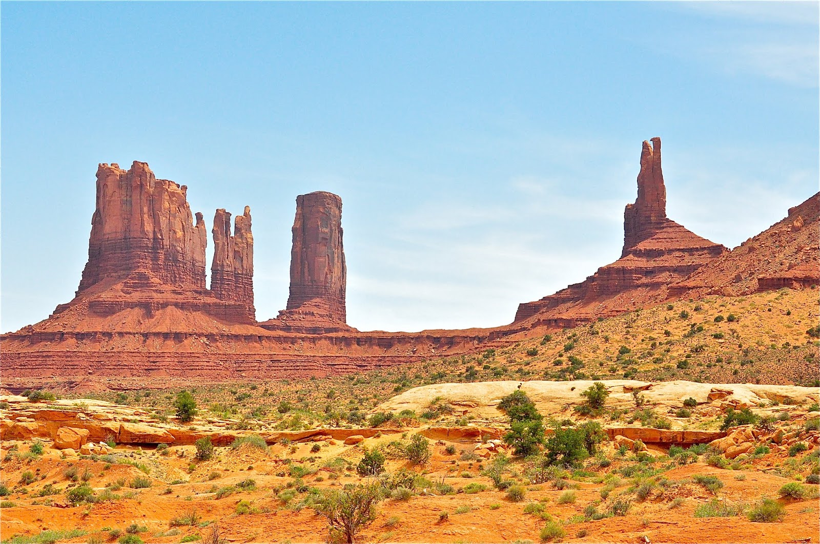
Credit: Linda & Dr. Dick Buscher
10. The Navajo section of the Colorado Plateau is home to the Four Corners area of the American Southwest. It is the central area of the Colorado Plateau with landscapes of high plateaus separated by arid, high desert valleys. Many national monuments like Canyon de Chelley and Navajo Tribal Parks like Lake Powell and Monument Valley, shown above, are located in this dramatic section of the Colorado Plateau.
Credit: Linda & Dr. Dick Buscher
11. Because of the eroding effect of the rivers that crisscross the Colorado Plateau, the many deep canyons found here are like an open textbook of geological time. Precambrian metamorphosed gneiss and schist lie exposed at the bottom of the Grand Canyon and whose ages are thought to be over 1600 million years. The brilliant colors of the thick layers of sandstone and limestone sedimentary rocks resulted from the 380 – 145 million year old ancient seas of the Permian. Triassic and Jurassic Periods and now sit atop the many sculptured plateaus and vast plains seen today.
Credit: Linda & Dr. Dick Buscher
12. The arid climate of the Colorado Plateau is the result of a rain shadow caused by the Sierra Nevada Mountains located to the west of the plateau. Average annual precipitation of rain and snow ranges from 6 to 16 inches (15 – 40 cm). In the higher elevations more precipitation occurs and results in forests of pine, spruce and fir.
Credit: Linda & Dr. Dick Buscher
13. The Colorado Plateau is a region of great ecological diversity. From thick riparian river banks lined with forests of cottonwood trees to miles and miles of dry desert basins covered with saltbush and greasewood; from grass covered mountain meadows to ponderosa pine covered mountain peaks – all varieties of nature’s botanical species are represented in this rugged, untamed wilderness. During late spring and early summer wildflowers abound all across the plateau.
Credit: Linda & Dr. Dick Buscher
14. The wildlife of the Colorado Plateau is as diverse as the landforms, vegetation and the climate. Collared lizards, elk, rattlesnakes, cougars, bobcats, jackrabbits, mule deer and more all roam across the land seeking to survive in this harsh environment. This collared lizard, shown here, is enjoying the springtime sun at Arches National Park.
Credit: Linda Buscher
15. A vast variety of birds fill the sky over the Colorado Plateau. Stellar jays, wild turkeys, various species of hawks and falcons are found here. Many migratory songbirds move across the Colorado Plateau each spring and fall. The Colorado Plateau is once again home to California condors that now again soar above the deep chasms of the Grand Canyon thanks to the successful efforts of a condor reintroduction program near the Vermillion Cliffs of northern Arizona.
Credit: Linda & Dr. Dick Buscher
16. American author and environmentalist Edward Abbey when asked about the uniqueness of the Colorado Plateau, stated that "there is no other region on earth much like it, or even remotely like it ... this is a landscape that has to be seen to be believed, and even then, when confronted directly by the senses, it strains credulity."
Credit: BLM
1. Slot canyons are narrow passages between towering walls of soft stone. Only a few places on earth have the right combination of geology, deserts climate and flash-flooding to carve such canyons in the earth so distinctly. They receive their name from their narrow width. All slot canyons are significantly deeper than they are wide at a ration at least 10:1 with some reaching a ratio as large as 100:1. Some slot canyons are so narrow that passage becomes impossible while others allow adventurers to walk within their depths for over of 20 miles (32 km). Most slot canyons are found in areas of sedimentary rock like limestone and sandstone. Under the right conditions, slot canyons can be carved in granite and basalt.

Credit: BLM
2. In North America, these labyrinth mazes in rocks, with their spectacular displays of light and shadow are clustered in the high desert of the Colorado Plateau along the border between Utah and Arizona. Each slot canyon is unique - some are tame and some are treacherous. Some allow for easy walking and the walls are always a few feet apart. Some are filled with ice-cold pools, scattered huge boulders and so narrow that the hiker must turn sideways to pass through. Utah claims title to having the largest concentration of slot canyons in the world. All slot canyons are formed by the force of running water rushing through the soft rock.

Credit: usgs.gov
3. One of the areas with spectacular slot canyon hikes is the Paria Canyon hike, a 38 mile (61 km) journey that follows the Paia River from southern Utah to Lee’s Ferry in northern Arizona. The trail through Paria Canyon is easy to follow as the majority of the hiking is done in the river bed. The trip gradually loses 1, 130 feet in elevation as the Paria River flows southward to join the Colorado River. The name “Paria” is a Paiute word and translates to mean “muddy” or “salty” water. Photo above shows the muddy water of the Paria River as it enters the Colorado River below Lee’s Ferry.

Credit: Linda & Dr.Dick Buscher
4. The Paria River is a tributary of the Colorado River and begins its 95 mile (153 km) journey in the Dr Seuss-like landscape of Bryce Canyon National Park, shown above, some 40 miles (64 km) north-northwest of Paria Canyon. The river cuts southeastward up and across the Paria Plateau. When the last ice age came to an end, the resulting water runoff from the ancient glaciers slowly cut deep into the soft regional sandstone resulting in the sublime and poetic formations of Paria Canyon.

Credit: BLM
5. Hikers through Paria Canyon witness the creative magnificence of 85 million years of creative geology. Layers of colorful sedimentary rocks, like the ones shown above, are opened like a geology textbook for those who take time to come and experience them. Swirling patterns of rocks known as the Wave have mesmerized generations of hikers who have come to Paria Canyon to witness them firsthand. The high desert sun adds a final touch to the landscape often highlighting the formations in such a way that one could envision a magnificent potter shaping and forming the whole canyon region.

Credit: Linda & Dr. Dick Buscher
6. The Paria River is the longest continuous flowing stream originating on the Colorado Plateau. Since stream flow monitors were first placed in the river in 1923, a steady flow of water has passed down the river and through the canyon. With such a nonstop source of water, a lush and vibrant riparian zone is found here. Fremont Cottonwoods create majestic stands along the river. Vegetation that is common away from the river and in more arid locations of Paria Canyon include Sweet Sand Verbena, Zion Sweetpea, Four-wing Saltbush, Arrow Weed and Indian Paint Brush, shown above.

Credit: BLM
7. The constant source of water provided by the Paria River allows for an abundance of animal life to live within and near by Paria Canyon. Rattlesnakes, chuckwallas and many species of lizard thrive here. Swifts, swallows, wrens, gnatcatchers, hummingbirds and herons are all found here. Predator birds such as falcons, hawks and owls hunt the many species of small mammals who make their homes in and near the lush riparian zone. The canyon is also near the release zone of endangered California condors, shown above, that once again soar above the many slot canyons of this region of the Colorado Plateau.

Credit: BLM
8. Long before Europeans “discovered” Paria Canyon, Native American people had used the floor of the canyon as a ancient highway by which they moved back and forth between southern Utah and northern Arizona. Archeological evidence suggests the the ancestors of the modern Paiute people have inhabited this region for more than 10,000 years. There is little evidence that the ancient people established permanent residence within Paria Canyon but there is abundant evidence that they often passed through the canyon leaving behind numerous petroglyphs, pictographs and various stone weapons.

Credit: Utah.gov
9. Buckskin Gulch, shown above, is one of the major tributaries of the Paria River. It is said to be the longest slot canyon in the world and is unique because of the length and depth of its ever changing narrows which go on uninterrupted for almost 15 miles (24 km). Buckskin Gulch is rarely more that 10 feet wide (3 m) and the spooky corridor is 400 feet deep (122 m) as it nears the junction with the Paria River. Danger of flash flooding make hiking Buckskin Gulch one of the most dangerous slot canyon hikes in the world. There is only one “escape hatch” from the canyon about 8 miles (13 km) into the journey. For those who enjoy the thrill of danger, hiking Buckskin Gulch is an experience never forgotten.

Credit: BLM
10. The slot canyons of Paria Canyon region are a part of the larger 112,000 acre (45,325 he) Paria Canyon-Vermillion Cliffs Wilderness Area. Created by the United States Congress’ 1984 Arizona Wilderness Act, the Bureau of Land Management and the National Park Service are empowered to preserve the regions natural conditions, opportunities for solitude and primitive recreation while preserving the areas educational, scenic and historical values. The entire region is now a part of the National Wilderness Preservation System.

Credit: NPS
11. This whole region has been one of great interest to the first Europeans who came upon it. The Spanish priests, Dominguez and Escalante, camped on the banks of the Paria River on October 27 - November 1, 1776 while trying unsuccessfully to find an easy way to cross the Colorado River. They soon left this area, traveling northeast before successfully establishing a crossing across the Colorado River at the famous Crossing of the Fathers site. Sadly the Crossing of the Fathers site is now beneath the waters of Lake Powell. A century latter, John D. Lee came to this area and in 1871 established a ferry, shown above, to allow travelers to cross the Colorado River. John D. Lee was one of the area’s most colorful and unique of historic figures, but his ferry was crucial for the areas travel and settlement. Today Lee’s Ferry is a favorite launching point for whitewater raft trips through Grand Canyon.

Credit: BLM
12. Recreation opportunities abound in the region of Paria Canyon. Beside the numerous opportunities for slot canyon hiking, the region has may spectacular geological formations to be enjoyed like the formation known as The Wave, shown above. The Wave, in North Coyote Buttes area of the Paria Canyon Wilderness, is actually two U-shaped troughs of Navajo Sandstone laid down during the Jurassic period. Hikers wanting to visit The Wave, need special permits, drawn by lottery, and are required by the Bureau of Land Management. But even if a permit to visit The Wave is not obtained, hikers and photographers visiting the Paria Canyon-Vermillion Cliffs Wilderness Area will cherish their experience of walking through one of the world most remote and beautiful of places.

Credit: BLM
13. Hiking through Paria Canyon is like a personal journey through time. The geological formations created by the forces of wind and water found during the entire length of the journey are breathtaking. The slot canyons, some of which ares so narrow that you can touch both walls as you walk through, always creates a feeling of smallness and awe as one looks up at the towering sheer sandstone cliffs above. As one recent hiker of Paria Canyon wrote, “nothing could prepare me for such incredible beauty. I don't know how many times I rounded a new bend and just said, Wow! ”
The Colorado Plateau is one of America's great geological wonders. For those who like dynamic, rugged landscapes, the Colorado Plateau is a rock-hound's Disneyland. Above is a map of the many national parks, national monuments and national recreational areas located on this fabulous 130,000 square mile geological wonderland. Soon we will begin posting a series of stories about these natural wonders found on the Colorado Plateau. Hope you get the chance to visit them all!
Credit: NPS
1. Glen Canyon National Recreation Area is located at the center of the Colorado Plateau and certainly ranks as one of the most beautiful and historically controversial areas under the guardianship of the National Park Service. When Glen Canyon Dam was completed in 1966, it backed up the water of the wild Colorado River to form magnificent Lake Powell, a reservoir capable of holding 24,322,000 acre feet (3.0001×10¹⁰ m3) of water. The waters of Lake Powell have created over 2,000 miles of shoreline along the Kayenta and Navajo Sandstone cliffs of Glen Canyon and resulted in the flooding of nearly 100 unique and beautiful side canyons.
Credit: NPS
2. The controversy concerning Glen Canyon Dam and Lake Powell began when the dam was first proposed in the early 1950s. Conservationist and environmentalist vehemently argued against the dam’s construction and the resulting flooding of beautiful Glen Canyon. Author Edward Abby championed the opposition to such dam construction and the inevitable destruction of the natural landscapes, archeological ruins and historic sites in his famous 1968 book, Desert Solitaire. The proponents of the dam and lake won the political debates resulting in the submerging of Glen Canyon, many side canyons and the creation of Lake Powell.
Credit: NPS
3. Glen Canyon National Recreation Area encompasses some 1.25 million acres (50,5857 ha) of water and backcountry related recreational opportunities. The recreational area stretches from the shores of historic Lees Ferry located below Glen Canyon Dam to the spectacular red cliffs of southern Utah - a distance of some 186 miles (299 km). The land offers an endless display of dazzling vistas and endless geological phenomenon.
Credit: NPS
4. Horseshoe Bend, shown above, is one of the unique geological phenomenon found within the Glen Canyon National Recreation Area. Located only 5 miles downstream from Glen Canyon Dam, Horseshoe Bend is in geological terns a horseshoe-shaped incised meander of the Colorado River. It is a classic and spectacular example of water following its natural path of least resistance. The sheer cliff rock walls are made of dense Navajo Sandstone and act as a natural barrier to the river flow, forcing the waters of the Colorado River to make a sharp turn and travel through softer rock. But Horseshoe Bend is not the only geological phenomenon in the area. Just a short 15 miles from the Lake Powell marinas is another spectacular geological treasure - a place simply known as Antelope Canyon.
Credit: City of Page.gov
5. Antelope Canyon is a slot canyon - a geological curiosity of tiny canyons formed when water seeps its way into fissures of the bedrock. Slot canyons are most common in desert areas. They are the result of many millennia of weather extremes. Antelope Canyon was thus formed over thousands of years of flash flooding of the intermittent creek running through it wearing away the Navajo Sandstone rock face before emptying into the Colorado River and now into Lake Powell. During the long periods of drought, wind blown sand would polish the narrow slot walls into a striated, swirling finish. Antelope Canyon is famous for its ever changing play of light upon its walls and the flowing sandfalls that cascade into the depths of the slot canyon.
Credit: Michael Buscher
6. From the surface of the earth, the fissure that open across the Navajo Sandstone is narrow and not exceptional to view. But first views can be deceptive. In the depths of the canyon, the walls can be 15 - 20 feet (5 - 7 m) apart like that shown above and the slot canyon itself can be a 100 feet (30 m) deep. Navajo Sandstone of Antelope Canyon was formed by aeolian depositions - sediment deposited by activity of the wind. Such depositions at Antelope Canyon began around 191 - 174 million years ago during the Jurassic Period. Iron oxide deposits were mixed with the wind blown sands resulting in layer after layer of varying shades of orange and red.
Credit: Michael Buscher
7. Rainwater near Antelope Canyon collects in an extensive basin above the beginning of the slot section. As gravity draws it downward toward Lake Powell, it picks up speed and sands while rushing into the narrow passageways of Antelope Canyon. Such annual and continual scouring of Antelope Canyon’s walls mean the canyon is in constant flux, slowly changing after each flush of gushing water that passes through it. Unique shapes are formed within the slot canyon like the one shown above that is known as “the heart.”
Credit: Michael Buscher
8. Antelope Canyon is actually divided into two sections - an Upper Antelope Canyon and a Lower Antelope Canyon. The Upper Antelope Canyon is the most famous and the easiest to access. The Navajo name for Upper Antelope Canyon is Tsé bighánílíní, which means “the place where water runs through rocks.” Upper Antelope Canyon is only about 100 yards (91 m) in length. It is located at an elevation of 4,000 feet (1219 m) and the walls of the Upper Antelope Canyon can rise some 120 feet (37 m) above the normally dry streambed. Thousands of tourists visit Upper Antelope Canyon each year partly because it is an easy, flat walk through the slot canyon.
Credit: Michael Buscher
9. Upper Antelope Canyon, also affectionally known as “The Crack”, is famous for the wave-like structure of the canyon’s walls. Upper Antelope Canyon is also known for the glorious light beams that penetrate into the depths of the canyon in the summer months between March 20 and October 7. The summer light beams that radiate into Upper Antelope Canyon result in this slot canyon being the most photographed slot canyon in the southwestern United States.
Credit: NPS
10. Some 4.5 miles (7 km) northwest of Upper Antelope Canyon is Lower Antelope Canyon - a slot canyon 1.1 miles (2 km) in length. The biggest difference between the two slot canyons is the size of the canyon floors. The upper canyon is wider at the bottom while Lower Antelope Canyon is much smaller at the bottom, almost V-shaped. The Navajo name for Lower Antelope Canyon is Hasdestwazi, meaning "spiral rock arches” and is sometimes called “The Corkscrew.” To enter the lower canyon requires a short walk over uneven rock surfaces then descending a series of 5 sets of stairs, shown above. Because of the challenging stairs, Lower Antelope Canyon usually sees less tourists than the upper canyon. But the fact remains that both the Upper Antelope Canyon and the Lower Antelope Canyon are a part of a complex, multi-faceted eco-system with multiple drainage streams that transport local moisture runoff into what is now Lake Powell.
Credit: Michael Buscher
11. The exact story into the discovery of Antelope Canyon seems to be lost to history. One Navajo tradition holds that a group of Navajo refused to join the “Long Walk” of 1864 and took refuge in Antelope Canyon where spiritual beings watched over them. Another story suggests that a young Navajo girl, while herding her sheep, walked into the slot canyon and was amazed by the shafts of light she saw there. For a fact, we know the canyon was first documented by a Utah photographer who began publishing photos of Antelope Canyon in the 1930s.
Credit: Sonoma State University
12. Access to the slot canyon of Antelope Canyon is today under the control of Navajo Nation. Authorized tour companies provide a variety of adventures for visitors to see and experience both the Upper and Lower Antelope Canyon. During the summer months, demand for the tours can be heavy and early morning tours are best to avoid the large crowds that at times gather.
Credit: nau.edu
13. Antelope Canyon is believed to have received its name from the herds of pronghorns, Antilocapra americana, that once grazed along the canyon’s rim during the winter months. The incredible slot canyons that laid below the grazing herds have been described by modern day visitors as the Eight Wonder of the World. “Absolutely breathtaking”, “awe-inspiring” and “words can’t describe it” are all comments from those whom have seen and experienced this geological jewel and treasure of the Glen Canyon National Recreation Area.