Friday, June 3, 2022

Humphreys Peak


                      Credit:  Linda & Dr. Dick Buscher

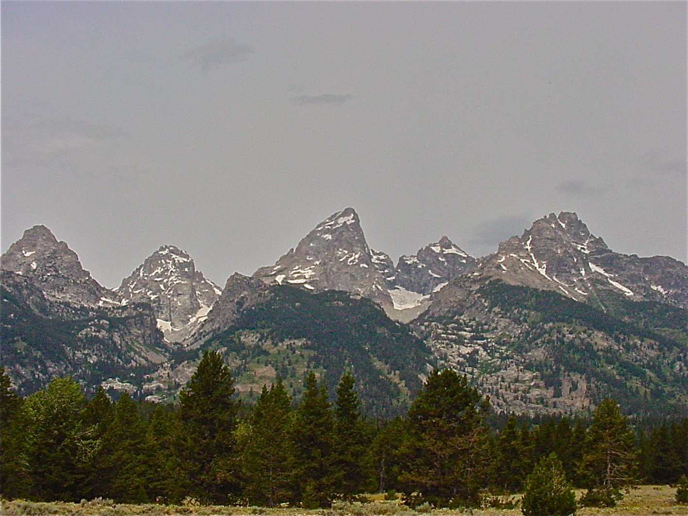
      The summer and fall months can be ideal times to put on your hiking boots and take on one of the most iconic trails in Arizona - the challenging assent to the 12,633 feet summit of Humphreys Peak.

                      Credit: NPS


         Humphreys Peak is one of six, volcanic mountains that together make up the magnificent San Francisco Mountain range just north of Flagstaff.  Geologist believe that today's San Francisco Mountains are the remains of an ancient cinder cone whose main crater once rose over 16,000 feet above the local landscape.  Some 200,000 to 400,000 years ago this mighty cone erupted in a thunderous roar resulting in the six lower peaks and volcanic landscape we see and enjoy today. 
    These six peaks are named and range in size from the tallest, Humphreys (12,633 ft), Agassiz (12,356 feet), Fremont (11,940 feet), Aubineau (11,818 feet), Rees (11,474 feet) and to the smallest,  Doyle (11,464 feet).  Some geologists argue that Rees Peak and Doyle Peak are actually false peaks whose prominences rise  merely some 200 feet above the saddle of Aubinuau Peak. 
    Humphreys Peak has been known by many names over the centuries.  The Navajo people call the mountains Dookʼoʼoosłííd) while the Hopi refer to them as Aaloosaktukwi and the Yavapai tribe calls them Wi:munakwa.  During the Spanish Conquistador exploration of this region in the mid-1500s, the conquistadors named the mountains Sierra Sinagua which translate to mean “mountains without water.”  In 1629 Spanish Franciscan Friars came into the area and renamed the volcanic mountains the San Francisco Mountains in honor of their patron saint, St Francis of Assisi.  This was some 100 years before the Presidio of San Francisco was founded in northern California.  But Humphreys - just where did the name Humphreys come from.  Like so many place names in Arizona, the name Humphreys has a close association to the events of the American Civil War. 

 
Credit: NPS


     General Andrew Atkinson Humphreys was a career US Army officer, civil engineer and Union General in the Army of the Potomac during the Civil War.  His grandfather, Joshua, is credited as the “Father of the American Navy” as Joshua designed and oversaw the construction of the first six U.S. warships including the historic USS Constitution, better known as “Old Ironside.” 

      Young Andrew Humphreys first came to the Arizona Territory as a Captain of the U.S. Army Topographical Engineers and where he was assigned to the Joseph Christmas Ives Expedition (http://mojavedesert.net/people/ives/ ) of 1857 - 1858.     This expedition became the first official U.S. Army reconnaissance group to see, document and explore the magnificent Grand Canyon while searching the northern section of the Arizona Territory for a possible trans-continental route for a railroad. 

     When the Civil War began, Captain Humphreys was assigned as an aide to General George McClellan as the Army of the Potomac’s chief topographical engineer.   He was put in charge of the Union’s 5th Corps and led these soldiers through the Battles of Antietam, Fredericksburg and Chancellorsville.  But it was his engineering work at the Battle of Gettysburg that might be his most significant contribution to the preservation of the Union.
        Captain Humphreys was transferred to the 1st Division of the 3rd Corps just before the July 1 - 3, 1863 Battle of Gettysburg.  Upon his arrival at Gettysburg, Commanding General John Reynolds ordered Humphreys and his engineers to examine the topography of the Gettysburg area and make recommendations for the best offensive and defensive lines that the Army of the Potomac could form to stop the attack of General Robert E. Lee’s Army of Northern Virginia.  This knowledge of the terrain and the resulting army placements proved to be a deciding factor in the Unions victory at Gettysburg. 

                           Humphreys Monument at Gettysburg   Credit: NPS


     Captain Humphreys came out of these campaigns commonly acknowledged to be one of the most capable officers of the Union Army.   On March 13, 1865 he was promoted to the rank of Brigadier General of the U.S. Army “For gallant and Meritorious service at the Battle of Gettysburg.”
    After the Civil War, Brigadier General Andrew A. Humphreys served as the U.S. Army's Chief of Engineers until his retirement on June 30, 1879.  He died an American Hero in his Washington, D.C. home on December 27, 1883.


                       Credit:  Linda & Dr. Dick Buscher


                                        G.K. Gilbert  -  Credit:  NPS

     So what does all this have to do with our Humphreys Peak?   The answer lies with Grove Karl Gilbert, better known as G.K. Gilbert, a famous American geologist who joined the John Wesley Powell Survey of the Rocky Mountain Region team as Powell’s primary assistant.  It was while Gilbert was with the Powell Expedition that he found himself in the summer of 1873 in the ancient volcanic fields of the Northern Arizona Territory.  He recognized that within the many volcanic cinder cones of this region, the tallest peak found in the Arizona Territory was located and that this peak needed an official, U.S. Government name.  He thought a moment and decided to name this magnificent 12,633 ft peak Humphreys Peak*** after the Civil War American hero who just happened to also be his superior officer, Brigadier General Andrew Atkinson Humphreys. 


                               Credit:  Linda & Dr. Dick Buscher


***Prepare well when deciding the climb the trail to the summit of Humphreys Peak.  Follow all common sense rules for hiking at a high altitude.  Be sure to take plenty of drinking water as there is no fresh water on the trail.  Good hiking shoes and appropriate clothing are a must - including a good hat.  Do not attempt to climb Humphreys Peak if summer thunderstorms are over the summit or in the area.  When you “Stand on Top of Arizona” you will truly be the tallest point in Arizona.


Wednesday, September 23, 2020

Navajo National Monument


Credit:  Linda & Dr. Dick Buscher
1.  Archeologists speculate that over 10,000 Native American ruin sites are scattered across the State of Arizona.  Some like Montezuma Castle National Monument, shown above, are highly refurbished and advertised by the National Park Service which oversees their preservation and protection.  Montezuma Castle National Monuments is located near an interstate highway in the Verde Valley of Arizona and receives over 400,000 visitors each year.    


Credit:  Linda & Dr. Dick Buscher
2.  Others are spectacular ruins, like the Honanki Heritage Site but are protected only by the 1906 Antiquity Act, state ordinances and local tour guides and volunteers.  Honanki Heritage Site is located in Loy Canyon near the tourist destination of Sedona, Arizona but has never received the influx of money needed to make it a designated national monument nor even a state park.  It, like so many other archeological ruins, survives after 800 years of existence trusting that vandals won’t ignore the laws and destroy it.


Credit:  Linda & Dr. Dick Buscher
3.  Many of Arizona’s archeological ruins are located on one of the 20 Indian Reservation that are found within Arizona.  Far too many continue to fall into desolation do to lack of resources as well as cultural considerations.  All are protected by the Antiquity Act as well as the laws of the local tribes who work hard to protect their cultural history.  Kinishba ruins, shown above, is located near historic Fort Apache in Whiteriver, Arizona on the White Mountain Apache Indian Reservation.  It is a large and spectacular ancient pueblo that was built between 1250 - 1350 CE but is challenged each year with more and more deterioration. 


Credit:  Linda & Dr. Dick Buscher
4.  Fortunately the federal government has designated 8 of the 20 national monuments found in Arizona to the preservation of ancient Native American sites.  One of the most remote yet impressive of these national monument is Navajo National Monument.  Located in the northwest section of the Navajo Nation in northern Arizona, Navajo National Monument protects and preserves three magnificent cliff dwellings built by the Ancestral Puebloan people during the 13th century. Each of the ancient pueblos are believed to have been constructed by a people named by the Navajo as the Anasazi.  We have no idea what the Anasazi called their cliff dwelling but the modern Navajo people have named the ruins Betatakin, Keet Seel and Inscription House. 


Credit:  Linda & Dr. Dick Buscher
5.  Navajo National Monument is relatively small in size - only some 360 acres (150 ha).  It is located on the Colorado Plateau at the transition zone between the Great Basin and Upper Sonoran deserts.  The climate tends to be hot and dry but at an elevation of 7,300 feet (2225 m), the winters can be very cold.  The national monument is located on a large plateau between Black Mesa, 20 miles to the southeast and Navajo Mountain, 30 miles to the northwest.


Credit:  Linda & Dr. Dick Buscher
6. Betatakin (Beh-TAH'-tah-kin), is the easiest of the three Navajo National Monument ruins to view and visit.  The pueblo sits nestled in an alcove of Jurassic-age Navajo sandstone mesa atop an underlying layer of the Kayenta Formation.  The top of the mesa rises some 7,200 feet (2,195 m) above sea level while the nearby canyon floor is at an elevation of 6,400 feet (1,951 m).  Betatakin is a Navajo word that means “ledge house”.  The cliff dwelling is located in Tsegi Canyon, one of a maze of canyons found across the Colorado Plateau and carved over the millennia by running streams. 


 Credit:  NPS
7.  The alcove in which Betatakin was built faces south to gather the warmth of the winter sun.  It is 452 feet (138 m) high and 370 feet (113 m) deep.  At the apex of its use, Betatakin was bustling pueblo of 135 rooms with a population of over 100 Anasazi.  The people were farmers, cultivating the nearby canyon floor with fields of corn and squash.  Today only 90 ancient rooms remain under the large rock ceiling.  Slabs of rocks falling from the ceiling of the alcove remain even today,  a problem and danger for those visiting the ancient pueblo. Only stabilization of walls has occurred at Betatakin with no reconstruction having taken place.


Credit:  NPS
8.   Keet Seel or Kiet Siel (Kįtsʼiil) is according to some archeologists the best preserved Anasazi ruin ever discovered.  When first seen, many visitors comment that it looks as if the pueblo was only recently abandoned.  Tree ring dating suggests that Keet Seel was built around 950 CE and abandoned around 1300 CE.  But to see this magnificent cliff dwelling is a challenge involving a strenuous 17-mile round trip hike with a drop of 1,000 feet (305 m) into the main branch of Tsegi Canyon by way of steep switchbacks before miles of hiking on sandy slopes, and wading through local streams while avoiding patches of quicksand. 


Credit:  NPS
9.  Kiet Siel is a Navajo word that translates to mean "broken pottery scattered around”.  Some 150 rooms are found at the ruins all constructed from sandstone blocks plastered together with mud.  Several kivas and pithouses are also found within the ruins.  Archeologists believe that most of the rooms were used for food storage while a few served as living quarters.  The estimated 150 people who once lived here grew a variety of food in their canyon floor fields that included beans, squash, corn and cotton.  Domesticated turkeys were also a part of the people’s food supply.  Skeletal remains of a macaw from southern Mexico was also found at Keet Seel.  The southeast facing alcove in which the pueblo was built greets the warm morning sun while providing early afternoon shade during the hot summer months.  


Credit:  NPS
10.  Inscription House is the third of the three magnificent cliff dwellings found in and protected at Navajo National Monument.  Unlike Betatakin and Keet Seel, Inscription House is found under a large, high arching sandstone cliff on the north side of a branch of Nitsin Canyon.  The ruins consists of only 74 rooms that include living quarters, granaries and one kiva. Tree-ring dating suggest that Inscription House was build around 1274 CE, about the same time as the other two larger pueblos of Navajo National Monument.  The Inscription House name is somewhat unusual rising from an inscription left on one of the ruin’s plastered walls and first noted in 1909 by two explorers, Byron Cummings and John Wetherill.  Later, Wetherill would recall that that inscription read “C H O S 1661 A d n”.  Today, Inscription House is closed to visitors due to the many unstable walls and the desire of local canyon residence for privacy. 


Credit:  NPS
11.  From the rim of Tsegi Canyon, visitors to Navajo National Monument can find the trails that lead to the ruins of both Betatakin and Keet Seel.  The view above from the rim looks for miles over canyon after canyon of Navajo sandstone which is actually a 200-million year old solidified sand dune left by the ancient seas that once covered this part of the southwestern United States.  Ancestors of the Hopi People lived in these canyons for thousands of years, long before the arrival of the Navajo.   The Hopi name for Keet Seel is Kawestima, meaning “snowy place” and was home to the Hopi Fire, Burrowing Owl, Flute, Deer, Snake and Bighorn Sheep Clans.  Betatakin is known as Talastime, meaning “place of the blue corn tassels”, and was home to the Deer, Fire, Flute and Water Clans.  Inscription House is called Tsu’ovi, meaning “place of the rattlesnake, and is home to the Rattlesnake, Sand and Lizard clans.  For the modern Hopi People, these ruins are spiritually active and a direct link to their ancestral past. 


Credit:  NPS
12. Because of its remote location, the spectacular cliff dwellings found at Navajo National Monument only receive around 105,000 visitors each year. But for those who choose to go “off the beaten path” and even enjoy a wilderness experience without large crowds,  the solitude, serenity and cliff dwellings found at Navajo National Monument are still a natural and historic treasures awaiting to be discovered and both emotionally and intellectually experienced.  


Credit:  USGS
13.  Navajo National Monument preserves and protects some of America’s best ancient cliff dwellings.  The Navajo say they were built by the Anasazi people; the Hopi say they were built by the Hisatsinom people and  modern archeologists refer to the builders as Ancestral Puebloans - three names for the same people.  We have no idea what the people called themselves but what they did without steel nor a domesticated animals larger than a dog is impressive even by today’s standards.  A 13th century drought probably drove the people from their alcove homes.  Lloyd Masayumptewa, a Hopi and a monument archeologist sums up best the challenge of living in this high Colorado Plateau land - “Rock – water – people. The mandala is no different for us than it was for them. They tried to cope with a long drought in the 1200s, as we cope now. And they knew that everyone lives in this country only with the blessing of the land and sky.”  


Sunday, August 2, 2020

Pronghorn Antelope - or not…


Credit:  City of Tucson
1.  In 1872 homesteader Dr. Brewster M. Higley left his Indiana home and moved to the prairie of Kansas to claim land under the Homestead Act of 1862.  His new home on the plains inspired his poetic creativity, penning a poem entitled “My Western Home” which was good enough to be published in the local newspaper in 1872.  A friend, Daniel E. Kelley, wrote a melody on his guitar for Dr. Brewster’s poem and the new song soon became a popular melody for both town folks and local range cowboys.  Higley’s poem/song spread across the American West in various versions with several local names before becoming universally known as “Home on the Range.”   Over the years it became the unofficial anthem of the American West and became immortalized as both a movie and hugely successful pop songs, sung by the likes of Gene Autry, Bing Crosby and Frank Sinatra. 


Credit:  NPS
2.  “Oh give me a home where the buffalo roam where the deer and antelope play….” say the lyrics, but there are no true antelopes in the Americas, as the true antelope species are found only in Africa and Southeast Asia.  But the “antelope-like” animals that Dr. Higley had written about and almost every American school kids has and continues to sing about is a hardy and cunning little creature known as the North American pronghorn.  The North American pronghorn, Antilocapra americana, is the only surviving member of a specific group of mammals that evolved in North America over the last 20 million years.  


Credit:  USDA
3.  Pronghorns are artiodactyl - even-toed ungulates. All species of the artiodactyla order are hoofed animals that support their weight equally on the third and fourth of their five toes.  There are some 220 land living artiodactyl in the world, including pigs, peccaries, camels, llamas, giraffes, hippopotamuses, sheep, goats and cattle.  Some pretty famous distant relatives of the pronghorns include aquatic artiodactyl species like whales, porpoises and dolphins - all of which evolved from even-toed ungulates.  


Credit:  NPS
4.  During the Pleistocene epoch of some 12.6 million - 11,700 years ago, some other 12 species of the pronghorn’s family Antilocapridae roamed across North America.  Three species beyond the pronghorn existed when modern man arrived in North America but all three of those species are now extinct.  Only the pronghorn survived as an indigenous mammal to the interior regions of western and central North America.  The animal has been called by various local names including prairie antelope, prong buck, American antelope and pronghorn antelope. 


Credit:  NPS
5.  Pronghorns are considered one of North America’s most impressive land animals.  They hold several impressive records such as having the longest land migration of any land animal in the continental United States traveling over 150 miles each way between Wyoming’s Upper Green River Basin and Grand Teton National Park.  Only the 1200 mile round trip journey of the great herds of caribou in the extreme northern regions of North America travel farther. 


Credit:  Linda & Dr. Dick Buscher
6.  Pronghorns are the fastest animal in North America and second fastest in the world only to the cheetahs of Africa.  Pronghorns can run upwards of 65 mph (105 kph) and can maintain that speed over long distances.  Pronghorns have large eyes which can see some 320 degrees around and thus their vision is considered excellent.   On the flat open prairies in which they live, they can see predators from far way and use their sensational speed to quickly move to safety.


Credit: Texas Farm Bureau
7.   Pronghorns have a body shaped like a deer with long legs, short tail and a long snout.  Their fur tends to  be in shades of brown to reddish-brown along with white markings on their face, stomach, rump and necks.  Their rumps have extra long hair that stand erect when the animal is frightened.  Adult males, like the one above, then to be about 4.5 feet (1.4 m) long, 3 feet (1 m) tall and weigh between 90 and 150 pounds (41 - 68 kg).  Both males and females have a pair of short horns.  The male’s horns are larger at around 10 - 12 inches (25 - 30 cm) in length.  Pronghorn’s horns point backward toward the rump except for a small notch or prong that points forward and gives rise to the animal’s name.   The outer materials of their horns are shed and regrown each year.


Credit:  NPS
8.  Pronghorns mate during late summer and early fall resulting in the females being pregnant during the winter months.  Males establish breeding territories and fight the males for breeding dominance.  Aggressive and heated physical conflict arise between competing males.  Once the dominant male is determined, he will breed with multiple females in the group.  Females have a gestation period of about 250 days.  One to two fawns are born in the following spring.  Fawns are basically helpless at birth, requiring a day of life before they can easily stand.  For this reason, fawns are very susceptible to predators at birth and must be protected by their mothers. 


Credit:  BLM
9.  Pronghorn fawns weigh about 4 - 12 pounds (2 - 5 kg) at birth.  Once they become steady on their legs, a pronghorn fawn will be able to sprint at a speed on nearly 25 mph (40 kph).  But for the first few days of life, the young fawns tend to stay hidden quietly in tall grasses while their mothers graze nearby.  After a week of nursing, both the does and the fawns rejoin the larger herd.  Male pronghorns play no role in the raising of the fawns.  Fawns will stay with their mothers for nearly a year before become totally independent.  Pronghorns are thought to have a lifespan in the wild of nearly 10 - 15 years. 


Credit:  Linda & Dr. Dick Buscher
10.  Pronghorns were once found on the open ranges  from Saskatchewan, Canada south to Mexico including all four deserts of the American Southwest.  Before the arrival of the Europeans, their numbers were in the millions.  For most Native American tribes of the West, pronghorns were a source of food, clothing, tools and shelter.  Within Apache traditions, the pronghorn was once a beautiful young woman who became a pronghorn and thus should never be hunted or harmed.  The Hopi pronghorn kachina is believed to bring rain and make the grasses grow.  The pronghorn, as a totem, focuses on knowledge and wisdom and assists one on their spiritual journey.  Shown above are pictographs of pronghorns found on a wall of Canyon de Chelly in northeastern Arizona.  


Credit: BLM
11.   Pronghorns cannot leap over fencing like a deer.  If a fence is encountered, they must crawl under, through  or go around it.  Thus they prefer grazing on the open plains, fields, grasslands of their vast western range.  Yet they can also be found forging in the deserts, and western basins like the yucca forest seen above.
Today the herds of pronghorns are mainly found in Wyoming, Montana, northeast California, southeast Oregon, Nevada, Utah, Colorado, Arizona and New Mexico.  One of the highest concentration of pronghorns today is found in Wyoming in the Red Desert and Yellowstone regions.


Credit: NPS
12.  Pronghorns are herbivores.  The eat the many grasses found on the open range as well as forms and sagebrush.  In fact, they can eat plants found in the grasslands that are toxic to domestic cattle.  They have a “two stomach” digestive system where they quickly eat and swallow the plant material and then at a later time, regurgitate the food in what is known as “cud”, chew it again breaking the plant material into smaller pieces so that more nutrients can be absorbed.  They seldom drink water as they receive all the water they need from the plants that they eat and digest.  Pronghorns are known to have gone months without drinking standing water at a watering hole or stream.


Credit: NPS
13.  When Dr. Higley wrote his magical poem about where “the deer and antelope play” there were still millions of pronghorns roaming free across the American West.  Today, biologists estimate that only some 700,000 pronghorn still roam free.  Fencing, coyotes, hunting and loss of habitat are the primary threats to this old and ancient resident of the American plains.  Active conservation efforts are found in every region where these beautiful and a amazing animals still trek.  Meriwether Lewis of the famous Lewis and Clark Expedition of 1804 - 1806 wrote of his fascination with the animal after an encounter with a herd of pronghorns, “I had this day an opportunity of witnessing the agility and superior fleetness of this animal, which was to me really astonishing.  When I beheld the rapidity of their flight along the ridge before me, it appeared rather the rapid flight of birds than the motion of quadrupeds.”  And even though the American pronghorn is not a true antelope as immortalized in Dr. Higley’s poem, it certainly remains a national treasure and a 20 million year old symbol of the American West.


Monday, July 13, 2020

Arizona's Granite Mountains

     Our previous story detailed how common granite was in the mountains of the American West.  Such granite mountains certainly show up across Arizona too. The hump of famous Camelback Mountain in Phoenix is composed mainly of granite.  Strangely, the head of the camel is composed of sedimentary rock, which forms from particles deposited on the floor of a body of water.   In between the formation of the hump and the head of the camel lies a vast gap in geologic time that’s even greater than Great Unconformity visible at the Grand Canyon.   Payson and Prescott are both areas with outcroppings of granite boulders.  The following is a May 14, 2016 article by Greg McKelvey from the Payson Roundup detailing the granite boulders of both communities. 

“Payson and Prescott have at least one thing in common, besides the longstanding rodeo wars.

We’ve both got granite fit to send a photographer into a frenzy.

Both offer the most distinctive of granite landscapes — a “dell” outfitted with mysteriously rounded, giant, sculptural granite boulders.

In Prescott, this landscape sets off Watson Lake and Willow Creek Reservoir, nearly as popular as Sedona with photographers. Easy to reach, convenient to lodging and good eats, these man-made lakes are known for their geomorphic feature, The Granite Dells.

Payson’s Granite Dells don’t get as much attention, but offer one of the region’s scenic treasures — which hikers, mountain bikers and horseback riders would love to turn into one of the region’s scenic attractions.

We encounter granite every day in many forms — including kitchen countertops. Igneous rocks are classified by their mineral composition and granite is but one of many igneous rocks. Stone slabbers and Home Depot give these same rocks more personal names like Norway blue. Gabbro, monzonite and the other geo stone words do not sell. That said, the Payson Dells are correctly classified a granite with just the right amount of quartz, two types of feldspar, mica and some iron-bearing minerals including magnetite.

Normally, to create a rounded boulder you have to tumble it down a river or stream. But granite often naturally erodes into giant spheres. Spheroidal weathering of rock occurs all over the world. OK, Watson, spheroidal weathering is a mouthful for the process that makes rocks round by ever so patiently removing all the corners.

The1.4-billion-year-old Dells’ granite in Prescott is a magma that formed a molten blob of rock some two miles beneath the surface. Still buried under tremendous pressure, the magma cooled slowly enough to crystallize as a uniform rock. As uplift pressed the layers toward the surface, the overlying rock layers eroded away. The stress of that rise created stress joints that cracked the rocks into cubes. Once the buried layers of once molten granite reached the surface, weathering along joints produced the rounded boulders typical of granitic terrains — including Payson’s own Granite Dells.

As an aside the Watson Lake Dells granite also boasts an unusually high uranium content.

Spheroidal weathering that creates secondary minerals of a larger volume. Water will penetrate the bedrock along joints, increase in mineral volume, swell up and widen the fractures. Eventually, these softer infiltrated minerals erode away. The weathering is greatest along the corners of each block, followed by the edges, and finally the faces of the cube. This process is not mechanical weathering, it’s chemical. Like Bunsen Honeydo said in “The Muppet Show,” better erosion through chemistry. 

The high water marks, called bathtub rings, are mineral deposits composed largely of calcium deposited as waters evaporated upon receding.

Our Payson Granite Dells waited like forever to be exposed to the surface and now they too are being reduced to sand. The Dells are dominated by large rounded boulders or outcrops rounded on the edges with piles of coarse sand piled up around the base, with the sand made of the same and only a sand at the base. A course sand, not like the fine sand on your favorite beach. Quartz, Feldspar, mica and black minerals as the granite. The minerals formed as the hot magma cooled in place to become granite. That happened deep under the surface.

The buried granite eventually made its way to the surface, where shifts in the earth created wide cracks.

Time continues to slip away and the cracks, called fractures, allow the slow, but oh so relentless, attack of water to channel down the fractures, removing the minerals grain by grain. There are no minions out there at night with hammers and chisels rounding the corners, it is the water! Life-giving water reduces even the hardest rocks to sand.

What makes the Dells so unique — both in Prescott and Payson — is that the landscape is made of just the big round boulders or sand, with little in between. The weathering of other types of rock like sandstone and limestone produces lose rocks of all sizes, from pebbles to boulders.

The result of spheroidal weathering at the Payson Dells is an open forest, since the weathered granite produces poor soil for the plants. This is work in progress and long after the last Roundup edition is published, there will be more sand and fewer boulders. The sand washes away as the mountain flattens. It is the water! So Dells need a dense granite, wide fractures, water and time to produce the landscape we see today. Eventually, the bits of granite will return to the sea where tectonic plates may well push them back under a continent to be melted, pushed up as hot magma, and start the cycle again.

The challenge to the photographer is the mainly the lighting. The boulder edges and fractures offer shadow and lines. Water reflections are just downright stunning. If there ever is a place for early morning and late afternoon tripod photography, it is Watson Lake.

I would like to try some night work, accepting that the lights of the greater Prescott metroplex will dim out some stars, there should be some good angles and perhaps even moonlight shots to take.

Payson’s own Granite Dells also offers a great place to photograph these natural, abstract sculptures.

If you want to wander further afield try the Stronghold granite in the Chiricahua Mountains, I-10 east of Benson, and along Arizona Highway 87 just before you reach the Valley.”

Link  - https://www.paysonroundup.com/outdoors/features/the-power-of-water-and-time/article_c3542962-fc51-5473-ade9-0aa29127627d.html


Camelback Mountain
The Dells of Prescott
Prescott Valley granite out croppings
Credit:  Payson Roundup
Chihuahua National Monument - Credit: NPS


Monday, June 29, 2020

Granite – Bedrock of the Earth


Credit:  Linda & Dr. Dick Buscher

1.  John Muir once described the Sierra Nevada Mountain Range of Central California as the “Range of Light” because of the reflected sunlight that always seems to glisten from the many majestic peaks.  He said that these majestic granite peaks were “so luminous, that it seems to be not clothed with light, but wholly composed of it, like the wall of some celestial city.”  


Credit:  Linda & Dr. Dick Buscher

2.  Granite is so common here that it is called the “stone heart of the Sierra.”  Geologists believe that these exposed mountain top granite peaks extend downward into the earths crust for over 20 miles.  In fact, granite is a prime product of tectonic plate collisions, forming the major part of the North American Continent’s foundation - the bedrock.  Massive outcroppings of granite can be found in over thirty states of the United States.  


 Credit:  Linda & Dr. Dick Buscher

3.  Granite is an igneous rock, formed by the solidification and cooling of magma some 20 – 140 miles below the earth’s crust.  In this underground region temperatures reach 1,500∞ C. forming pockets of liquid magma. Three factors come into play, allowing the magma to begin its journey toward the surface; the underground lithostatic pressure, some 35,000 times greater than atmospheric pressure, the magma being less dense than the surrounding solid rock, resulting in the magma “floating” upward and the melting of adjacent rock during its upward journey creating spaces into which the magma flows.


Credit:  Linda & Dr. Dick Buscher

4.  As the magma cools to about 1000∞ C, small crystals of minerals such as feldspar, quartz, mica and more begin to form.  The process is very slow and as the different mineral crystals begin to grow together, they begin to create an interlocking atomic framework.  After a long cooling period, the molten magma solidifies, creating a hard stone made totally of inter-grown crystals.  It is these interlocking crystals that give granite its unique glitter and sparkle.


Credit:  Linda & Dr. Dick Buscher

5.  Some of the highest mountain ranges in the world (the Andes, the Himalayas as well as the Rockies) are composed of massive granite mountains.  In the United States, both Mt. Whitney (14,505ft/4,421m) and Mt. McKinley (20,320 ft/ 6,194m) are both granite plutons, part of an even more massive granite blatholith.  And when the forces of erosion begin to remove softer rock layers interspersed with the hard granite, magnificent valleys are formed like the Yosemite Valley shown here.  


Credit:  Linda & Dr. Dick Buscher

6.  In the Yosemite Valley the force of erosion responsible for carving such a natural paradise were massive glaciers.  For the last 30 million years glaciers have moved into and then retreated from the valley.  The last period of glaciation occurred during the Pleistocene Epoch ending only 11,700 years ago.  Ahead of the advancing ice is pushed tons of gravel, sand and granite boulders known as till which marks the end of the glacial advance.  


Credit:  Linda & Dr. Dick Buscher

7.  Other forces of erosion and weathering are always working to tear down the massive granite mountains and outcroppings.  Exfoliation joints of sheet joints are parallel surface fractures in granite rock that lead to the “peeling off” of the rock surface similar to that of peeling off the layers of an onion.  Exfoliation joints are common in many different geological areas and geologists continue to work on an agreeable theory of exfoliation joint formation. 


Credit:  Linda & Dr. Dick Buscher

8.   Exfoliation has causes the formation of some of the most spectacular of granite mountain features known as granite exfoliation domes.  These unique natural structures are found in granite mountain ranges worldwide.  From Corcovado Mountain in Rio de Janeiro, Brazil, to Stone Mountain in American state of Georgia, to Half Dome (shown here) of the Sierra Nevada Mountains, granite domes create awe-inspiriting natural features unique to granite.  


Credit:  Linda & Dr. Dick Buscher

9.  In many areas where granite bedrock is close to the surface, topsoil is very shallow.  Plant roots, like those of this ponderosa pine tree (Pinus ponderosa), seek any small crack in the hard granite rock to anchor the majestic tree to the hillside.   The intrusion of plant roots continues the weathering process of these great, granite mountains.  


Credit:  Linda & Dr. Dick Buscher

10.  Tree roots and lichen work on this group of granite boulders in the mountainous areas near Keystone, South Dakota.  These forms of biological weathering work with the forces of erosion to constantly break down the massive mountains of granite   


Credit:  Linda & Dr. Dick Buscher

11.  The Grand Teton is the highest mountain in the Grant Teton National Park of Wyoming.  Here silica-rich magma crystallized deep underground and the moved upward to form the park’s highest granite peaks. 


Credit:  Linda & Dr. Dick Buscher

12.  El Capitan is a granite monolith found in Yosemite National Park.  It rises some 3,000 feet (900 m) from the floor of the Yosemite Valley.  The coarse grain granite that makes up the marvelous wall is approximately 100 million years old.  It is the largest monolith of granite in the world.


Credit:  Linda & Dr. Dick Buscher

13.  El Capitan is also one of the favorite rock climbing venues in the world.  It was first climbed in 1958 and today over 70 big wall routes allow climbers from all over the world to make the ascent.  The 3,000-foot climb has been made in less than 2 hours but the average climbing party takes between 4 – 6 days.  During the climbing season, from spring to fall, dozens of climbers can be seen on the face of this granite giant, moving slowly toward the towering summit.


Credit:  Linda & Dr. Dick Buscher

14.  The granite mountains of the world are not only used by outdoor enthusiasts but also by the world’s great rock sculptors.  The giant heads of the four American Presidents were carved by Gutzon and Lincoln Borglum into the granite face of Mt Rushmore in South Dakota.  The Precambrian period batholith magma rose into pre-existing mica schist some 1.6 billion years ago resulting in this granite outcropping.  Carving of the monument began in 1927 and was stopped in 1941.


Credit:  Linda & Dr. Dick Buscher

15.  Thus is the story of the granite, a major product of tectonic plate collision.  Mankind has used it for centuries to build his homes as well as his most spectacular buildings.  And, because it is so naturally hard, it has resisted the forces of erosion and weathering for eons resulting in the formation of some of the most spectacular places on earth.